Travel Guide to Bryce Canyon National Park

Of all the National Park’s in the state of Utah, Bryce Canyon is probably the smallest in terms of size. But it is definitely packed with ample beauty all around. The entire scenery feels like poetry since the landscape at the Park keeps changing depending on the time of the day. The views at this park are so surreal and divine like no other.
Our Top Picks
Did You Know?
Bryce Canyons are unique in every sense as they are carved by ice forming cracks in the rocks.
Bryce Canyon National Park is smallest in terms of size of all the national park's in the state of Utah.
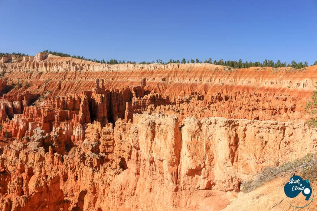
Main Rock Formation in the Park are Hoodoos- which are bulbous columns carved out due to the erosion of thin walls of rocks called fins.
Ready to plan your trip - Check out these details!
Visitor Center is always our first stop whenever we visit any National Park, to know about the current trail conditions and other details right from the Park Rangers. Sunset, Sunrise, Inspiration and Bryce point together are referred to as “Bryce Amphitheater” area. This area is definitely the best area of the park with amazing panoramic views of the canyons in the park.
Our recommendation is to cover all the viewpoints in the Amphitheater area of the park and then continue with the other viewpoints in the park.


Sunrise and Sunset Point
Sunrise Point is the first viewpoint as you drive south from the visitor center. It is at 8017 ft and near to the Bryce Lodge Canyon and the North Campground Store. From Sunrise Point, you will see the first glimpses of the beautiful red, pink sandstone hoodoos scenery.
Spend some time soaking in the views and if you fancy a hike Queens Garden trail (~ 2 miles out and back) starts from this viewpoint, which is an easier hike into the canyon. After Sunrise point, make a stop at Sunset Point. The panoramic views of the canyons and the rock formations kept following us from Sunrise Point, but the colors of the hoodoos are more vivid from this point.
Navajo Loop trail is a highly recommended hike from this point. You will witness the park’s iconic Thor’s Hammer, two bridges and Wall street section. Wall Street section is the only slot canyon area of the park. During Winter, this section of the trail is closed. The trail is a 1.3 miles loop. Definitely, one of the best viewpoint in the park where you can spend a good amount of time.
If you have more time in hand, you can combine the Queen’s Garden trail and Navajo loop for a hike of ~3 miles. This is by far the most popular hike in the park, so expect a lot of foot traffic.


A maze of hoodoos in the backdrop and striking view of the Thor's Hammer
Thor's Hammer
This rock spire formation is truly iconic in every sense. Its a great stop for some amazing pictures. Moreover, looking at this spectacular hoodoo, it makes you wonder the amazing powers of nature around us!

Views of the distinctive tall Thor's Hammer from Navajo trail
Within half a mile into the trail, you will be right in the hearts of the sand dunes with almost all the dunes for yourself! The white unbroken vistas of the sand dunes are something, you won’t see anywhere else in the park. Some of the dunes in this area are more than 2-3 story height of a building.

Panaromic view from Inspiration Point at Bryce Canyon National Park
Inspiration Point
Inspiration point is the next not to be missed viewpoint of the park. This viewpoint is at 8100ft and as the name suggest the views from this point will truly inspire you and make you appreciate nature more. You can see the Silent City (near Sunset Point) containing rows of seemingly frozen hoodoos set against the backdrop of Boat Mesa.


Bryce Point
Bryce Point is famous for its dazzling sunrises. This point is at 8296 ft. It is one of the most scenic vistas of the park. You will see grottos from this point, which are the result of erosion of softer pockets of the upper white members of the Clarion formation.

Views of varying density of vegetation with the far views of Grand Staircase
Agua Canyon
Home to the huge Ponderosa Pine trees on the canyon floor. From this vantage point, you will be surprised to see Bryce Canyon surrounded by so much of forest around it.
Two prominent Hoodos “ The Hunter” and “Rabbit/backpacker” reside in Agua Canyon area of the park.
Natural Bridge is more than the bridge, it is an arch. The formation is truly incredible and one of the many good spots to capture through your lens. On a clear day, from this point, you will see most of the plateaus surrounding the park, even Kaibab Plateau which lies in North Rim of Grand Canyon. Due to high air quality in the park, there is a potential to view the Black Mesas in Arizona some ~160 miles away from this point.


Never ending canyon view from the Rainbow point
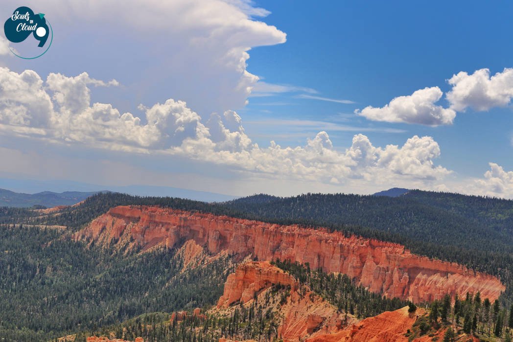
Rainbow and Yovimpa Point
Rainbow and Yovimpa Point are the southernmost viewpoints on the scenic Bryce Road. From the Bryce Amphitheater area, we drove straight to this area.
These points showcase the most noteworthy geological and geographical orientation of the parks, thereby helping you to understand the landscape of the park. At Yovimpa point you can see the sequence of rock layers called Grand Staircase.
Stroll around the 1-mile bristlecone loop, that takes you through the ancient forest. Two backpack hikes also start from this point – Riggs spring loop (8.8 miles) and Under the Rim (22.9 miles).
Mossy Cave
Mossy Cave is located at the northern end of the park on scenic Highway 12 approximately 4 miles east from the intersection of Highway 12 and 63. After crossing a small bridge, there is a small parking area on the right side for Mossy Cave Trail. Even though there is no signage for the parking lot you will always see a lot of parked vehicles.
The trail is short (0.9 miles) and the cave is at the end of the trail. Along with the cave, you will also see a gorgeous waterfall at the end of the trail.
As you start the trail, you will notice the broken and random hoodoos structures atop the canyon on one side, with water flowing in the canyon below. After crossing a couple of water bridges, you will arrive at a fork. Turning left will take you the cave.
Mossy Cave is a shelter cave, created by underground spring. As a result, depending on the season, you can see large sheets of moss or giant icicles hanging from above the cave’s roof. Turning Right from the fork will take you to the waterfall. This area is known as Tropic Ditch – an irrigation canal dug by Mormon Pioneers in late 1800s.
This area is located outside the Park’s scenic drive, so we recommend you to visit the area after completing your adventure inside the Amphitheater area.


The entire park can be easily covered in a day with at least one hike in the itinerary. The charm of the colorful hoodoos and the great air quality in the park transports you to a different magical place altogether. In other words, Bryce Canyon holds a very special place in our hearts.
We visited the park during the Summer. At the visitor center, we saw some pictures of the Park’s landscape during winter and it was absolutely out of this world! Therefore, we would definitely pack our bags to visit this park again during winters to experience the winter wonderland this park has to offer. Stay tuned for more of our sparkling moments!
Plan your visit
-
Late Spring and Early Fall are the best time to visit the Park. Summer is the busiest time of the Park.
-
SLC (274 miles north) and LAS(260 miles southwest) are the closest large commercial airport.
From Capitol Reef National Park, Bryce is just ~ 110 miles.
-
Before your visit, check any of the park alerts here.
The Scenic Drive inside the park (UT-63 S) is an 18-mile one-way paved road which provides access to all the viewpoints and trailheads. The viewpoints are located on the east side of the road, so we suggest, if you only plan to do an auto tour, directly head to Rainbow point (at the end) and stop at viewpoints as you head north on your return trip.
Summer days are hotter in the park, so carry enough water and sunscreen with you.
During the peak season, park runs a shuttle, between Ruby’s Inn 9 (outside the park) and Bryce Point, covering the most prominent viewpoints of the park.
NPS website has a trip itinerary to help visitors enjoy the park to the fullest based on the time they have to spend.